One of the most sought-after services in recent times, LiDAR- Light Detection & Ranging, is a remote sensing method used to examine the surface of the earth. It’s touted as one of the most accurate & effective technologies for the creation of 3-Dimensional topographical aerial maps.
Since the demand for LiDAR services has gone up for capturing geodata, the use of Helicopters has significantly increased for this service. Why Helicopters? You see, Helicopters can access areas that are not possible to reach otherwise. Moreover, they can hover over an area under inspection & capture the required data from different angles & perspectives, which can help in acquiring higher resolution imagery, covering a much wider area from the air in a much shorter time than it would be possible to cover by land. Also, helicopters are much more manoeuvrable in high winds and high altitudes than UAVs (drones), and most importantly they can equip and fly LiDAR equipment which is currently not possible with UAVs.
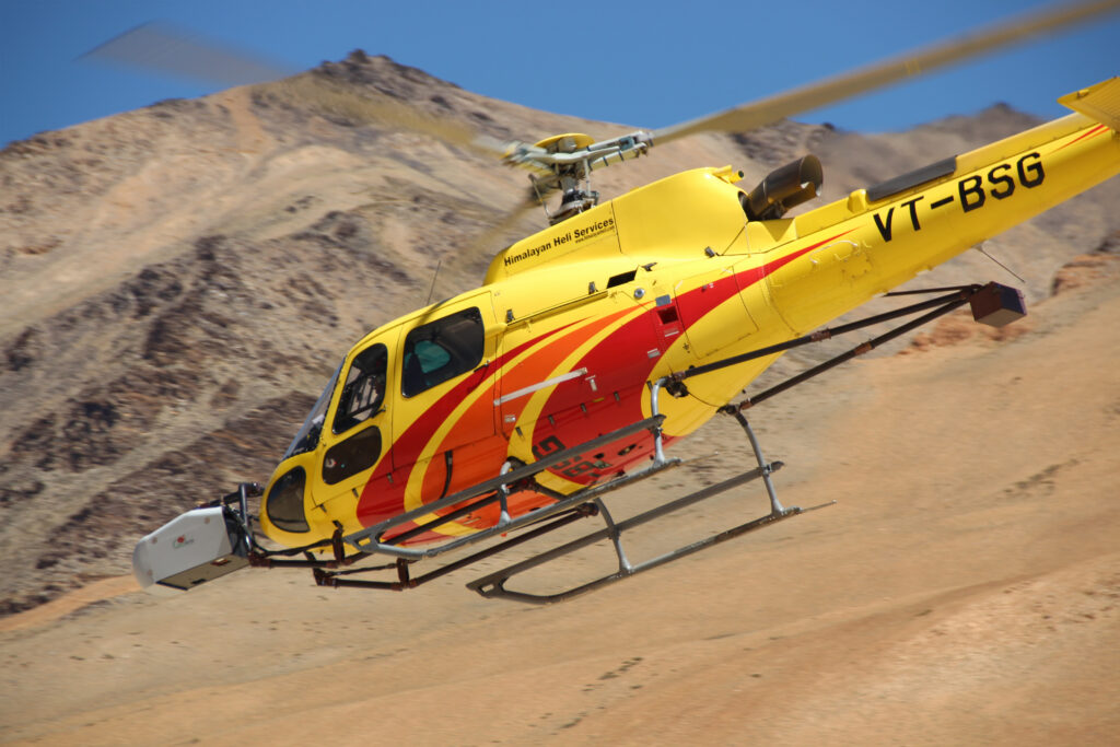
Now, for over two decades, Himalayan Heli has been operating Aerial work service s in India for important Government Organisations and leading private giants. After providing a vast range of reliable & dedicated heli-services for so long, we are touted as India’s leading helicopter company in the Aerial work industry, which is one of our primary segments of heli-services.
Most of the surveys are being operated from remote locations in India. The incredible amount of experience & technical know-how of logistics involved in conducting remote-based Aerial Survey operations is something that sets Himalayan Heli apart. Our exceptionally experienced crew of pilots, engineers, and ground support team are highly trained in providing precision low-level flying for mapping and aerial surveys.

Off-late, amidst the COVID19 pandemic, our team successfully executed a LiDAR survey operation which was initially thought impossible due to the various challenges pertaining to the project. But what fun would it be, if there were no challenges?
In August 2020, our team of experts set out to conduct the First Aerial Survey in the UT of Ladakh. Such an operation had never been conducted by a Civil helicopter operator in that region before. The regions of Ladakh which were covered during the operation were:
1. Sindhu Ghat, Leh: Situated at an altitude of 10,600 ft. ASL, this was the first base of our operation where we operated for a week.
2. Rumtse: Our second base, Rumtse, was situated at an altitude of 14,300 ft. ASL. We operated from the Rumtse base for over a week, before shifting to our next base.
3. Pang: Our third base, was the second-highest base of the entire operation. Situated at an altitude of 14,800 ft. ASL, we operated from Pang for nearly 2 weeks in total. During the operations at Pang, we even got to fly over Tanglang La (17,480 ft.) – the second highest motorable road in the world.
4. Tsokar: Our last operations base in Ladakh, Tsokar was the highest point from where we operated. Situated at 15,800 ft. ASL, we operated only for a couple of days, after which we moved back to Pang to finish the Ladakh job for our clients.

Followed by Ladakh, was the Survey Job in Himachal Pradesh, where we started our operations from a place called Jispa. The entire Aerial Lidar survey operation in Ladakh and Himachal was part of a single project, which was done in two separate parts: Part 1 – Ladakh, Part 2 – Himachal.
This entire operation went on for over a month.
Ladakh being the most difficult part of the project is certainly more memorable for our team. Being one of the highest and most remote parts of our country, Ladakh posed several operational & logistical challenges for us, such as:
• All the survey locations were above 10,000 ft., there was a huge risk of Acute Mountain Sickness (AMS) for our crew members. To avoid that, our crew members had to acclimatize by reaching 3 days prior to commencement of operations.
• High Altitude Flying was the most challenging part of the project. The altitudes that we operated at, were all over 10,000 ft. Therefore, carrying the equipment load at these locations had to be very strategically done at the time of fuel planning, so that maximum production flying could be done at one go for our clients.
• Low Oxygen pressure in high altitude locations results in breathing difficulty, therefore oxygen cylinders were being used by the crew for breathing whenever the oxygen level was felt low. The flying crew was using oxygen cylinders onboard during their sorties. Hydration had to be ensured too at all times so that oxygen levels are maintained.
• The temperature used to go to sub-zero levels, which was as low as -10 to -5° C at night time, and highest to 20°c during day time. Changing wind speeds – sometimes high, sometimes low, high altitude and freezing temperatures were the important factors that made fuel planning challenging for the crew.
• Because of the lack of infrastructure in such remote areas, our team put up in tents throughout the operation in Ladakh, where we managed our own kitchen for the entire crew at each base campsite.
• Due to less or even zero mobile connectivity in these remote locations, crew positioning was another challenging task. Some of the team members were stationed at different locations during the operation to maintain the connectivity between the base camp and other locations. Moreover, the team members remained cut off from the outside world for the most part of the operation in Ladakh.
• Also, since this operation was done in August 2020, soon after the un-lockdown last year, arranging logistics & transportation of goods was a tedious & difficult barrier throughout the operation as things were still not running smoothly at that time.
• And, despite the seriousness of the COVID19 situation at that time, our team managed to operate with 100% safety to avoid any safety hazards during the operations.
Here is the video of our operation, to give you a glimpse of the whole project:
For our Ladakh aerial survey operation, we can certainly say that we pushed the limits of Man & Machine, and that is why we were truly at the cutting edge of Aviation. And understanding the complexities & nuances of remote base aerial work operations, we were able to deliver the desired work for our clients even in the most challenging terrains & conditions.
Apart from Ladakh & Himachal, we have operated Aerial LiDAR surveys in various other parts of India such as Goa, U.P., Bihar & Chattisgarh, among other States.
In the past decades or so, we have garnered a niche clientele of tech-companies like Geokno India, Network Mapping Solutions UK & Sterlite (Vedanta Group).
To know more about our clientele: https://www.himalayanheli.com/clientele.php
Some of our other primary sought-after aerial work services include:
• Aerial Geophysical Surveys with Time-Domain Electromagnetic Systems
• Helicopter Underslung External Load Operations
• Powerline Stringing
• Aerial Filming
• Search and Rescue
• Pipeline Inspections & Surveys, among others.

To get to know more about our services: https://www.himalayanheli.com/aerial-work.php
For regular updates about Himalayan Heli, do visit our Website, Instagram, Facebook, YouTube & LinkedIn.
Team Himalayan Heli !